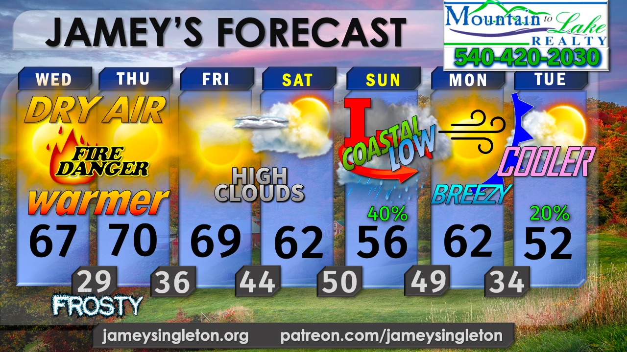
...WINTER WEATHER CHANCES CREEPING IN BY THANKSGIVING BUT DETAILS ARE FUZZY... ...SUNNY AND WARMER IN THE MEANTIME IN THE DAY... ...COLD AND FROSTY AGAIN TONIGHT... ...COASTAL LOW COULD BRING CLOUDS AND RAIN BY SUNDAY...
Sponsored By: The Kingery Team at Mountain to Lake Realty 540-420-2030 BillyKingery.com
Don't be surprised if colder and wintry weather arrives earlier than usual this season, perhaps near Thanksgiving and/or into December due to the sudden amplification of the jet stream coupled with the release of cold, Arctic Air from the north into the Mid Atlantic by early December. No single storm stands out, but wintry mix and or snow may indeed form in the 8-14 day range due to some of the Polar Vortex pushing into a strengthening Southern branch of the jet stream from the Pacific to the gulf and up the coast.
In other words, the pattern for wintry weather will be better with time but the details are kinda fuzzy right now, which is normal. I'm watching Thanksgiving and the week after closely.
In the meantime, the quiet before any craziness as a massive dome of high pressure sits right on top of us, squashing any moisture and cloud cover; adding to the stubborn drought (again) for Southside VA into North Carolina south of Danville to Kerrs Lake.
Sun persists daily, through today and Thursday with an increase in high white cirrus clouds Friday.
Temps warm both afternoons with highs today and Thursday 65-70, despite frosty morning lows in the 20's. That's dry air for you. The lack of moisture means wild swings from night to day.
The clouds Friday arrive thanks to an elongated slug of tropical moisture across Cuba and Florida where super cell storms over the open waters off the Florida Keys today hug a stalled front, then congeal into one, maybe two areas of low pressure into the rest of the week. One low may form and move NW into the gulf, while another forms on the east coast of Florida, possibly flooding the already-soaked "sunshine state", then perhaps taking on SUBTROPICAL or Tropical characteristics late Saturday into Sunday off the NC/SC coast, moving inland Sunday. How far inland isn't certain but there's a chance we could see rain from a more inland track Sunday, showing up on many reliable models such as the Euro.
If you have any plans from Florida to the Gulf Coast and along the SE Coast from Charleston to Myrtle Beach to Wilmington to the Outer Banks and inland into down east Carolina you should closely monitor the track and trends in the low pressure system for the late part of the weekend into early next week.
Rain should clear out as a cold front moves closer Monday and gets through the area Tuesday. This front will be carrying MUCH COLDER air behind it. That's important, bc there MAY be more southern stream gulf energy with the southern branch of the jet stream that may throw moisture into the colder air by Thanksgiving and into early December. Some areas may see a little wintry mix or snow by Turkey Day or if not then - in the coming 1-2 weeks of December if the current trends continue.
Stay tuned!
Original Facebook source: Open post
Source note: Star News TV · Nov 18, 2026 6:27 PM.
Community
Discussion
No comments yet. Be the first to respond to this report.